Identity area
Reference code
Title
Date(s)
- 1903 - 1925 (Creation)
- 1891-01-01 - 1989-09-02 (Accumulation)
Level of description
Medium
Format
Status
Context area
Name of creator
Administrative history
The Department of Lands and Surveys was one of the oldest government agencies in Western Australia, having been constituted under the name of the Survey Office in 1829. The Office became the Surveyor-General's Department in 1870 and was organized into two branches - Crown Lands and Surveys. The Department was administered by the Surveyor-General who also held the title of Commissioner of Crown Lands.
The Department was restyled the Crown Lands and Surveys Department in 1873 and, in 1890, the Department of Land and Surveys.
The Department of Lands and Surveys was responsible for the leasing and alienation of Crown Lands (except where mining and forestry tenures were involved*), the reservation of land for public purposes and roads, the surveying and classifying of land, and the exploration and mapping of the State. From its inception, the Department was also active in promoting immigration and settlement, and until 1973 was responsible for administering various Assisted Passage Immigration Schemes.
Immigration remained one of the functions of the Department until 1986, and the Department was responsible for the administration of the Noalimba Reception Centre.
Following a functional review, the Department was reorganized and renamed the Department of Land Administration in 1986.
- Initially, the Department was responsible for virtually all aspects of land administration, but with the establishment of the Department of Mines (1893) and the Forests Department (1919), it relinquished control of mining and forestry matters.
Repository
Archival history
Content and structure area
Scope and content
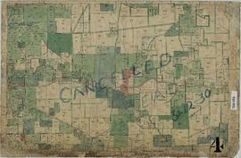
This series consists of 40 Chain Cancelled Public Plans of the South Western section of Western Australia. The scale is 40 chains to one inch and the plans are based on the Bonne Modified Conical Projection.
Before 1903, Public Plans of most of the areas covered by this series were drawn on sheets of the 80 Chain Series (see Record Series No. 981).
From 1903, sheets of the 40 Chain cadastral series were used as bases for the Public Plans.
In 1925, sheets of the plans in this series were continued on 20 Chain sheets. Other sheets on larger scale were introduced gradually. In the early 1970s the plans on 40 Chain were systematically continued on sheets of the new State Large Scale Mapping.
The title of individual plans in this series consist of the (80 Chain) sheet number, followed by a letter (A, B, C, D) denoting the quadrant of the 80 Chain sheet.
The sheets are hand coloured and annotated on photolithographic bases (app. 63cm x 95cm), linen backed, some on acetate bases. Following the end of physical map creation, the maps were created as coloured aperture cards, a form of microfiche.